
Make a donation
Garmisch-Partenkirchen topographic map
Click on the map to display elevation.
Make a donation
Garmisch-Partenkirchen
Garmisch-Partenkirchen leans towards an oceanic climate, and its winters are colder than the rest of Bavaria. Due to its higher elevation, it is very close to the winters associated with continental climates; it has a relatively wet and snowy climate, with high precipitation year-round. As of 2013 the regions in the west and east of the town were cited as having highest numbers of thunderstorm days in Europe.
Make a donation
About this map
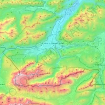
Name: Garmisch-Partenkirchen topographic map, elevation, terrain.
Average elevation: 1,326 m
Minimum elevation: 633 m
Maximum elevation: 2,945 m
Make a donation
Other topographic maps
Click on a map to view its topography, its elevation and its terrain.
Zugspitze
Germany > Bavaria > Landkreis Garmisch-Partenkirchen > Grainau
The mountain rises eleven kilometres southwest of Garmisch-Partenkirchen and just under six kilometres east of Ehrwald. The border between Germany and Austria runs over the west summit; thus the Zugspitze massif belongs to the German state of Bavaria and the Austrian state of Tyrol. The municipalities…
Average elevation: 2,300 m