
Quincy topographic map
Interactive map
Click on the map to display elevation.
About this map
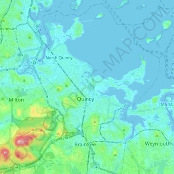
Name: Quincy topographic map, elevation, terrain.
Location: Quincy, Norfolk County, Massachusetts, United States (42.20418 -71.09319 42.31381 -70.93774)
Average elevation: 19 m
Minimum elevation: -5 m
Maximum elevation: 153 m
Other topographic maps
Click on a map to view its topography, its elevation and its terrain.
Germantown
United States > Massachusetts > Norfolk County > Quincy
Germantown, Quincy, Norfolk County, Massachusetts, 02191, United States
Average elevation: 5 m
Houghs Neck
United States > Massachusetts > Norfolk County > Quincy
Houghs Neck, Quincy, Norfolk County, Massachusetts, 02191, United States
Average elevation: 2 m
Needham
United States > Massachusetts > Norfolk County
Needham, Norfolk County, Massachusetts, United States
Average elevation: 46 m
Dedham
United States > Massachusetts > Norfolk County
Dedham, Norfolk County, Massachusetts, United States
Average elevation: 43 m
Avon
United States > Massachusetts > Norfolk County
Avon, Norfolk County, Massachusetts, 02322, United States
Average elevation: 60 m
South Quincy
United States > Massachusetts > Norfolk County > Quincy
South Quincy, Quincy, Norfolk County, Massachusetts, 02269, United States
Average elevation: 25 m
Rock Island
United States > Massachusetts > Norfolk County > Quincy
Rock Island, Quincy, Norfolk County, Massachusetts, 02191, United States
Average elevation: 3 m
Norwood
United States > Massachusetts > Norfolk County
Norwood, Norfolk County, Massachusetts, 02062, United States
Average elevation: 37 m
Braintree
United States > Massachusetts > Norfolk County
Braintree, Norfolk County, Massachusetts, 02184, United States
Average elevation: 39 m
Cohasset
United States > Massachusetts > Norfolk County
Cohasset, Norfolk County, Massachusetts, 02025, United States
Average elevation: 8 m
East Weymouth
United States > Massachusetts > Norfolk County > Weymouth
East Weymouth, Weymouth, Norfolk County, Massachusetts, 02189, United States
Average elevation: 21 m
Houghton's Pond
United States > Massachusetts > Norfolk County > Milton
Houghton's Pond, Milton, Norfolk County, Massachusetts, United States
Average elevation: 76 m
Buckmaster Pond
United States > Massachusetts > Norfolk County > Westwood
Buckmaster Pond, Westwood, Norfolk County, Massachusetts, United States
Average elevation: 67 m
Wrentham
United States > Massachusetts > Norfolk County
Wrentham, Norfolk County, Massachusetts, 02093, United States
Average elevation: 78 m
Westwood
United States > Massachusetts > Norfolk County
Westwood, Norfolk County, Massachusetts, 02090, United States
Average elevation: 59 m
Milton
United States > Massachusetts > Norfolk County
Milton, Norfolk County, Massachusetts, United States
Average elevation: 41 m
Wethersfield
United States > Massachusetts > Norfolk County > Bellingham
Wethersfield, Bellingham, Norfolk County, Massachusetts, 02019, United States
Average elevation: 76 m
Blue Hills
United States > Massachusetts > Norfolk County > Milton
Blue Hills, Milton, Norfolk County, Massachusetts, 01286, United States
Average elevation: 32 m
Brookline
United States > Massachusetts > Norfolk County
Brookline, Norfolk County, Massachusetts, United States, Olmsted Park
Average elevation: 28 m
Canton
United States > Massachusetts > Norfolk County
Canton, Norfolk County, Massachusetts, United States
Average elevation: 44 m
Medway
United States > Massachusetts > Norfolk County
Medway, Norfolk County, Massachusetts, 02053, United States
Average elevation: 60 m
Great Blue Hill
United States > Massachusetts > Norfolk County > Canton
Great Blue Hill, Canton, Norfolk County, Massachusetts, 02187, United States
Average elevation: 75 m
Quincy Point
United States > Massachusetts > Norfolk County > Quincy
Quincy Point, Quincy, Norfolk County, Massachusetts, 02169, United States
Average elevation: 12 m
Oakdale
United States > Massachusetts > Norfolk County > Dedham
Oakdale, Dedham, Norfolk County, Massachusetts, 02026, United States
Average elevation: 29 m
Ashcroft
United States > Massachusetts > Norfolk County > Dedham
Ashcroft, Dedham, Norfolk County, Massachusetts, 02026, United States
Average elevation: 30 m
Medfield
United States > Massachusetts > Norfolk County
Medfield, Norfolk County, Massachusetts, 02052, United States
Average elevation: 57 m
Blue Hills Reservation
United States > Massachusetts > Norfolk County > Quincy
Blue Hills Reservation, Quincy, Norfolk County, Massachusetts, United States
Average elevation: 48 m
Brookline
United States > Massachusetts > Norfolk County
Brookline, Norfolk County, Massachusetts, United States
Average elevation: 35 m
Weymouth Heights
United States > Massachusetts > Norfolk County > Weymouth
Weymouth Heights, Weymouth, Norfolk County, Massachusetts, 02191, United States
Average elevation: 15 m
Boston Harbor Islands National Recreation Area
United States > Massachusetts > Norfolk County > Weymouth
Boston Harbor Islands National Recreation Area, Weymouth, Norfolk County, Massachusetts, United States
Average elevation: 1 m
Bellingham
United States > Massachusetts > Norfolk County > Bellingham
Bellingham, Norfolk County, Massachusetts, 02019, United States
Average elevation: 84 m
Wellesley
United States > Massachusetts > Norfolk County
Wellesley, Norfolk County, Massachusetts, United States
Average elevation: 52 m
Stoughton
United States > Massachusetts > Norfolk County > Stoughton
Stoughton, Norfolk County, Massachusetts, United States
Average elevation: 66 m
Plainville
United States > Massachusetts > Norfolk County
Plainville, Norfolk County, Massachusetts, 02762, United States
Average elevation: 79 m
Medfield
United States > Massachusetts > Norfolk County
Medfield, Norfolk County, Massachusetts, 02052, United States
Average elevation: 60 m
Birds Hill
United States > Massachusetts > Norfolk County > Needham
Birds Hill, Needham, Norfolk County, Massachusetts, 02027, United States
Average elevation: 43 m
Walpole
United States > Massachusetts > Norfolk County
Walpole, Norfolk County, Massachusetts, United States
Average elevation: 62 m
Millis
United States > Massachusetts > Norfolk County
Millis, Norfolk County, Massachusetts, 02054, United States
Average elevation: 51 m
Weymouth
United States > Massachusetts > Norfolk County
Weymouth, Norfolk County, Massachusetts, United States
Average elevation: 28 m
Quincy
United States > Massachusetts > Norfolk County > Quincy
Quincy, Norfolk County, Massachusetts, 02169, United States
Average elevation: 28 m
Atlantic
United States > Massachusetts > Norfolk County > Quincy > Atlantic
Atlantic, Quincy, Norfolk County, Massachusetts, 02171, United States
Average elevation: 7 m
Franklin
United States > Massachusetts > Norfolk County > Franklin
Franklin, Norfolk County, Massachusetts, United States
Average elevation: 80 m
North Commons
United States > Massachusetts > Norfolk County > Quincy
North Commons, Quincy, Norfolk County, Massachusetts, 02269, United States
Average elevation: 26 m
Sabrina Lake
United States > Massachusetts > Norfolk County > Wellesley
Sabrina Lake, Wellesley, Norfolk County, Massachusetts, United States
Average elevation: 45 m
Corey Hill
United States > Massachusetts > Norfolk County > Brookline
Corey Hill, Brookline, Norfolk County, Massachusetts, 02446, United States
Average elevation: 30 m
Randolph
United States > Massachusetts > Norfolk County > Randolph > Randolph
Randolph, Norfolk County, Massachusetts, 02368, United States
Average elevation: 58 m
Medway
United States > Massachusetts > Norfolk County > Medway > Medway
Medway, Norfolk County, Massachusetts, 02053, United States
Average elevation: 63 m
City Mills
United States > Massachusetts > Norfolk County > Norfolk > City Mills
City Mills, Norfolk, Norfolk County, Massachusetts, 02056-1409, United States
Average elevation: 66 m
Norfolk
United States > Massachusetts > Norfolk County > Norfolk
Norfolk, Norfolk County, Massachusetts, United States
Average elevation: 64 m
Braintree
United States > Massachusetts > Norfolk County > Braintree > Braintree
Braintree, Norfolk County, Massachusetts, 02184, United States
Average elevation: 39 m