
Make a donation
Smith Peak topographic map
Click on the map to display elevation.
Make a donation
About this map
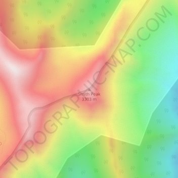
Name: Smith Peak topographic map, elevation, terrain.
Location: Smith Peak, Elko County, Nevada, United States (40.66033 -115.33385 40.66043 -115.33375)
Average elevation: 2,943 m
Minimum elevation: 2,483 m
Maximum elevation: 3,374 m
Make a donation
Other topographic maps
Click on a map to view its topography, its elevation and its terrain.
Ruby Mountains
United States > Nevada > Elko County
The Ruby Mountains (Shoshoni: 'Duka Doya', meaning “Snowcapped”) are a mountain range, primarily located within Elko County with a small extension into White Pine County, in Nevada, United States. Most of the range is included within the Humboldt-Toiyabe National Forest. The range reaches a maximum…
Average elevation: 1,962 m
Make a donation
Wells
United States > Nevada > Elko County
According to the United States Census Bureau, the city has a total area of 6.9 square miles (18 km2), all land, at an elevation of 5,630 feet (1,720 m).
Average elevation: 1,744 m
Wells
United States > Nevada > Elko County
According to the United States Census Bureau, the city has a total area of 6.9 square miles (18 km2), all land, at an elevation of 5,630 feet (1,720 m).
Average elevation: 1,744 m
Make a donation