
Thank you for supporting this site ❤️
Make a donation
Make a donation
Carris topographic map
Click on the map to display elevation.
Thank you for supporting this site ❤️
Make a donation
Make a donation
About this map
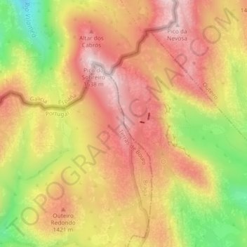
Name: Carris topographic map, elevation, terrain.
Location: Carris, Campo do Gerês, Terras de Bouro, Braga, Portugal (41.81396 -8.04895 41.81406 -8.04885)
Average elevation: 1,356 m
Minimum elevation: 1,095 m
Maximum elevation: 1,531 m
Thank you for supporting this site ❤️
Make a donation
Make a donation
Other topographic maps
Click on a map to view its topography, its elevation and its terrain.