
Thank you for supporting this site ❤️
Make a donation
Make a donation
Gistel topographic map
Click on the map to display elevation.
Thank you for supporting this site ❤️
Make a donation
Make a donation
About this map
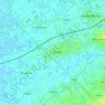
Name: Gistel topographic map, elevation, terrain.
Location: Gistel, Ostende, Flandre-Occidentale, Flandre, 8470, Belgique (51.11039 2.87372 51.19715 3.00055)
Average elevation: 2 m
Minimum elevation: -2 m
Maximum elevation: 15 m
Thank you for supporting this site ❤️
Make a donation
Make a donation
Other topographic maps
Click on a map to view its topography, its elevation and its terrain.