
Thank you for supporting this site ❤️
Make a donation
Make a donation
Fajã de Cima topographic map
Click on the map to display elevation.
Thank you for supporting this site ❤️
Make a donation
Make a donation
About this map
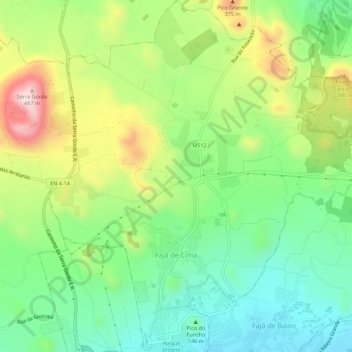
Name: Fajã de Cima topographic map, elevation, terrain.
Location: Fajã de Cima, Ponta Delgada, Açores, 9500-516, Portugal (37.75696 -25.68019 37.80091 -25.62827)
Average elevation: 204 m
Minimum elevation: 42 m
Maximum elevation: 480 m
Thank you for supporting this site ❤️
Make a donation
Make a donation
Other topographic maps
Click on a map to view its topography, its elevation and its terrain.