
Geißlingen topographic map
Interactive map
Click on the map to display elevation.
About this map
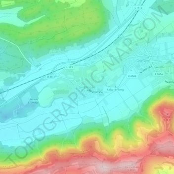
Name: Geißlingen topographic map, elevation, terrain.
Average elevation: 454 m
Minimum elevation: 363 m
Maximum elevation: 685 m
Other topographic maps
Click on a map to view its topography, its elevation and its terrain.
Rechberg
Deutschland > Baden-Württemberg > Landkreis Waldshut > Klettgau > Rechberg
Rechberg, Klettgau, Landkreis Waldshut, Baden-Württemberg, 79771, Deutschland
Average elevation: 453 m
Grießen
Deutschland > Baden-Württemberg > Landkreis Waldshut > Klettgau > Grießen
Grießen, Klettgau, Landkreis Waldshut, Baden-Württemberg, 79771, Deutschland
Average elevation: 447 m