
Thank you for supporting this site ❤️
Make a donation
Make a donation
Shaw topographic map
Click on the map to display elevation.
Thank you for supporting this site ❤️
Make a donation
Make a donation
About this map
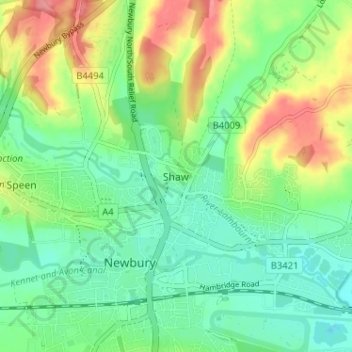
Name: Shaw topographic map, elevation, terrain.
Location: Shaw, West Berkshire, England, RG14 2DF, United Kingdom (51.39178 -1.33580 51.43178 -1.29580)
Average elevation: 93 m
Minimum elevation: 64 m
Maximum elevation: 143 m
Thank you for supporting this site ❤️
Make a donation
Make a donation
Other topographic maps
Click on a map to view its topography, its elevation and its terrain.
Thank you for supporting this site ❤️
Make a donation
Make a donation
Newbury
United Kingdom > England > West Berkshire
Elevations vary from a minimum of 72 m above mean sea level to 122 m at Wash Common. Elevations reach 150–200 m in the directly adjoining hills. The River Kennet and the Kennet and Avon Canal flow east through the centre of the town to reach the Thames at Reading, while the River Lambourn (beside which is…
Average elevation: 97 m
Thank you for supporting this site ❤️
Make a donation
Make a donation