
Eden Prairie topographic map
Interactive map
Click on the map to display elevation.
About this map
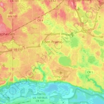
Name: Eden Prairie topographic map, elevation, terrain.
Location: Eden Prairie, Hennepin County, Minnesota, United States (44.79855 -93.52090 44.89226 -93.39837)
Average elevation: 259 m
Minimum elevation: 208 m
Maximum elevation: 313 m
In 1853, John H. McKenzie and Minnesota Territory secretary Alexander Wilkins platted the town of Hennepin along the Minnesota River in what is now southeastern Eden Prairie. According to area historian Helen Holden Anderson, topographic disadvantages for the transport of agricultural goods caused Hennepin to be eclipsed by other towns in the region, and the town soon vanished from maps.
Other topographic maps
Click on a map to view its topography, its elevation and its terrain.
Fred Richards Park
United States > Minnesota > Hennepin County > Edina
Fred Richards Park, Edina, Hennepin County, Minnesota, 55435, United States
Average elevation: 259 m
Bloomington
United States > Minnesota > Hennepin County
Bloomington, Hennepin County, Minnesota, United States
Average elevation: 255 m
New Hope
United States > Minnesota > Hennepin County
New Hope, Hennepin County, Minnesota, 55428, United States
Average elevation: 278 m
Plymouth
United States > Minnesota > Hennepin County
Plymouth, Hennepin County, Minnesota, United States
Average elevation: 294 m
Corcoran
United States > Minnesota > Hennepin County
Corcoran, Hennepin County, Minnesota, United States
Average elevation: 292 m
Minneapolis
United States > Minnesota > Hennepin County
Minneapolis, Hennepin County, Minnesota, United States
Average elevation: 270 m
Orono
United States > Minnesota > Hennepin County
Orono, Hennepin County, Minnesota, 55323, United States
Average elevation: 292 m
Maple Grove
United States > Minnesota > Hennepin County
Maple Grove, Hennepin County, Minnesota, United States
Average elevation: 278 m
Grays Bay
United States > Minnesota > Hennepin County > Minnetonka
Grays Bay, Minnetonka, Hennepin County, Minnesota, 55391, United States
Average elevation: 288 m
Edina
United States > Minnesota > Hennepin County
Edina, Hennepin County, Minnesota, United States
Average elevation: 271 m
Medicine Lake
United States > Minnesota > Hennepin County > Plymouth
Medicine Lake, Plymouth, Hennepin County, Minnesota, United States
Average elevation: 278 m
Shorewood
United States > Minnesota > Hennepin County > Tonka Bay
Shorewood, Tonka Bay, Hennepin County, Minnesota, 55331, United States
Average elevation: 292 m
Wayzata
United States > Minnesota > Hennepin County
Wayzata, Hennepin County, Minnesota, United States
Average elevation: 291 m
St. Anthony
United States > Minnesota > Hennepin County
St. Anthony, Hennepin County, Minnesota, United States
Average elevation: 286 m
Brooklyn Park
United States > Minnesota > Hennepin County
Brooklyn Park, Hennepin County, Minnesota, United States
Average elevation: 265 m
Oak Knoll
United States > Minnesota > Hennepin County > Minnetonka
Oak Knoll, Minnetonka, Hennepin County, Minnesota, 55305, United States
Average elevation: 288 m
Eden Prairie
United States > Minnesota > Hennepin County > Eden Prairie > Eden Prairie
Eden Prairie, Hennepin County, Minnesota, 55347, United States
Average elevation: 267 m
Long Lake
United States > Minnesota > Hennepin County
Long Lake, Hennepin County, Minnesota, 55356, United States
Average elevation: 300 m
Richfield
United States > Minnesota > Hennepin County > Richfield
Richfield, Hennepin County, Minnesota, 55419:55420, United States
Average elevation: 259 m
Wood Lake Nature Center
United States > Minnesota > Hennepin County > Richfield
Wood Lake Nature Center, 6710, Lakeshore Drive, Richfield, Hennepin County, Minnesota, 55423, United States
Average elevation: 260 m
Minnetonka
United States > Minnesota > Hennepin County > Minnetonka
Minnetonka, Hennepin County, Minnesota, United States
Average elevation: 290 m
Edinborough
United States > Minnesota > Hennepin County > Edina
Edinborough, Edina, Hennepin County, Minnesota, United States
Average elevation: 261 m
Maple Plain
United States > Minnesota > Hennepin County
Maple Plain, Hennepin County, Minnesota, United States
Average elevation: 304 m
Richfield
United States > Minnesota > Hennepin County
Richfield, Hennepin County, Minnesota, 55423, United States
Average elevation: 261 m
Crystal
United States > Minnesota > Hennepin County
Crystal, Hennepin County, Minnesota, 55429, United States
Average elevation: 273 m