
Make a donation
Mausbach topographic map
Click on the map to display elevation.
Make a donation
Mausbach
Bereits Mitte September 1944 wurde der Ort von den Amerikanern genommen. Die ausgewichenen deutschen Soldaten richteten sich auf dem beherrschenden Höhenrücken des Weißenberges und in Gressenich zur Verteidigung ein, so dass ein weiteres Vordringen der Amerikaner erst ab Mitte November möglich wurde. In diesen „Stolberg-Korridor“ lieferten sich zwei Monaten lang beide Seiten verlustreiche Kämpfe. Dabei erlitt unter anderem die 12. Infanterie-Division der Wehrmacht hohe Verluste. Eine Evakuierung der Zivilbevölkerung war nicht angeordnet worden.
Make a donation
About this map
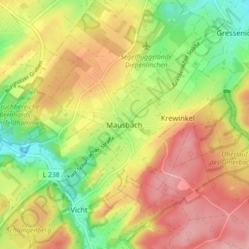
Name: Mausbach topographic map, elevation, terrain.
Average elevation: 270 m
Minimum elevation: 202 m
Maximum elevation: 332 m
Make a donation
Other topographic maps
Click on a map to view its topography, its elevation and its terrain.
Vichtbachtal mit Grölis-, Schlee- und Lensbach
Deutschland > Nordrhein-Westfalen > Städteregion Aachen > Stolberg > Vicht
Average elevation: 376 m