
Echo Park topographic map
Interactive map
Click on the map to display elevation.
About this map
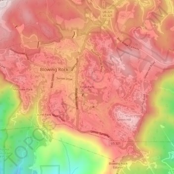
Name: Echo Park topographic map, elevation, terrain.
Average elevation: 1,051 m
Minimum elevation: 712 m
Maximum elevation: 1,223 m
Other topographic maps
Click on a map to view its topography, its elevation and its terrain.
Moses H Cone Memorial Park
United States > North Carolina > Watauga County > Blowing Rock
Moses H Cone Memorial Park, Blowing Rock, Watauga County, North Carolina, 28605, United States
Average elevation: 1,121 m
Green Hill
United States > North Carolina > Watauga County > Blowing Rock > Green Hill
Green Hill, Blowing Rock, Watauga County, North Carolina, 28605, United States
Average elevation: 993 m