
Québrux topographic map
Interactive map
Click on the map to display elevation.
About this map
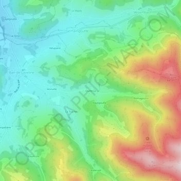
Name: Québrux topographic map, elevation, terrain.
Average elevation: 575 m
Minimum elevation: 397 m
Maximum elevation: 920 m
Other topographic maps
Click on a map to view its topography, its elevation and its terrain.
les Mirabelliers
France > Grand Est > Vosges > Ban-de-Laveline > les Mirabelliers
les Mirabelliers, Ban-de-Laveline, Saint-Dié-des-Vosges, Vosges, Grand Est, France métropolitaine, 88520, France
Average elevation: 510 m
Marimont
France > Grand Est > Vosges > Ban-de-Laveline
Marimont, Ban-de-Laveline, Saint-Dié-des-Vosges, Vosges, Grand Est, France métropolitaine, 88520, France
Average elevation: 481 m