
Make a donation
South Downs National Park topographic map
Click on the map to display elevation.
Make a donation
South Downs National Park
The South Downs National Park's chalk downland is a feature that sets it apart from other national parks in Britain. However, almost a quarter (23%) of the national park consists of a quite different and strongly contrasting physiographic region, the western Weald, whose densely wooded hills and vales are based on an older Wealden geology of resistant sandstones and softer clays. The highest point in the national park, Blackdown, at 280 m (919 ft) above sea level, is in fact situated in the Weald, on the Greensand Ridge, whereas the highest point on the chalk escarpment of the South Downs, Butser Hill, has an elevation of 271 m (889 ft) above sea level.
Make a donation
About this map
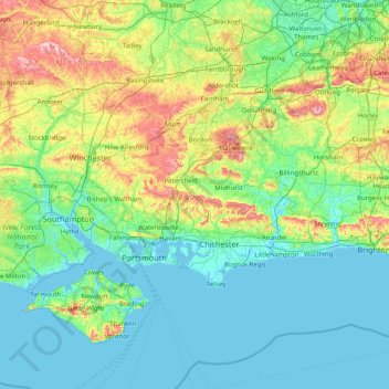
Name: South Downs National Park topographic map, elevation, terrain.
Location: South Downs National Park, West Sussex, England, United Kingdom (50.73324 -1.33670 51.19343 0.27259)
Average elevation: 54 m
Minimum elevation: -3 m
Maximum elevation: 297 m
Make a donation
Other topographic maps
Click on a map to view its topography, its elevation and its terrain.
Sullington Warren
United Kingdom > England > West Sussex > Horsham > Storrington
Average elevation: 54 m
Make a donation
Make a donation
Gay Street
United Kingdom > England > West Sussex > Horsham > West Chiltington
Average elevation: 38 m
Make a donation
Washington Common
United Kingdom > England > West Sussex > Storrington > Washington
Average elevation: 61 m
Make a donation
Felbridge
United Kingdom > England > West Sussex > Mid Sussex > East Grinstead
Average elevation: 98 m
Make a donation
Make a donation
Ardingly Reservoir
United Kingdom > England > West Sussex > Mid Sussex > Ardingly
Average elevation: 98 m
Make a donation
Make a donation
Henry Burt Wood
United Kingdom > England > West Sussex > Mid Sussex > Burgess Hill
Average elevation: 39 m
Make a donation
Make a donation
Make a donation
Make a donation
Worth Abbey
United Kingdom > England > West Sussex > Mid Sussex > Turners Hill
Average elevation: 124 m
Make a donation
Make a donation
Make a donation
Make a donation
Make a donation
Make a donation
Make a donation
Make a donation
Make a donation
Make a donation
Make a donation
Make a donation
Smock Alley
United Kingdom > England > West Sussex > Horsham > West Chiltington Common
Average elevation: 38 m
Twineham Green
United Kingdom > England > West Sussex > Mid Sussex > Hickstead > Twineham Green
Average elevation: 21 m
Make a donation