
Thank you for supporting this site ❤️
Make a donation
Make a donation
Cursani topographic map
Click on the map to display elevation.
Thank you for supporting this site ❤️
Make a donation
Make a donation
About this map
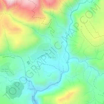
Name: Cursani topographic map, elevation, terrain.
Location: Cursani, Municipio Tiraque, Tiraque, Cochabamba, Bolivia (-17.46988 -65.78917 -17.46531 -65.78147)
Average elevation: 3,028 m
Minimum elevation: 2,884 m
Maximum elevation: 3,284 m
Thank you for supporting this site ❤️
Make a donation
Make a donation