
Thank you for supporting this site ❤️
Make a donation
Make a donation
Carnières topographic map
Click on the map to display elevation.
Thank you for supporting this site ❤️
Make a donation
Make a donation
About this map
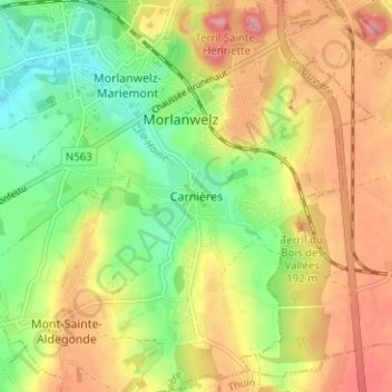
Name: Carnières topographic map, elevation, terrain.
Average elevation: 141 m
Minimum elevation: 82 m
Maximum elevation: 204 m
Thank you for supporting this site ❤️
Make a donation
Make a donation
Other topographic maps
Click on a map to view its topography, its elevation and its terrain.
Parc de Mariemont
Belgique > Hainaut > La Louvière > Morlanwelz > Morlanwelz-Mariemont
Average elevation: 134 m
Thank you for supporting this site ❤️
Make a donation
Make a donation