Fayzabad topographic map
Interactive map
Click on the map to display elevation.
About this map
![Fayzabad topographic map, elevation, terrain](/pub/maps/relation/79f3/m4tdrr/thumbnail.jpg)
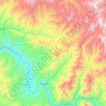
Name: Fayzabad topographic map, elevation, terrain.
Location: Fayzabad, Badakhshan, Afghanistan (37.04996 70.44279 37.37120 70.76038)
Average elevation: 2,134 m
Minimum elevation: 1,075 m
Maximum elevation: 3,680 m
Other topographic maps
Click on a map to view its topography, its elevation and its terrain.
![Hindu Kush topographic map, elevation, terrain](/pub/maps/node/79f3/g54lgckl/icon.jpg)
Hindu Kush
Hindu Kush, Wakhan, Badakhshan, Afghanistan
Average elevation: 5,164 m
![Darwaz topographic map, elevation, terrain](/pub/maps/node/kh1h/lmjs4j4s/icon.jpg)
Darwaz
Afghanistan > Badakhshan > Darwaz
Darwaz, Darwaz-e Pa'in, Badakhshan, Afghanistan
Average elevation: 2,365 m