
Thank you for supporting this site ❤️
Make a donation
Make a donation
Hickory topographic map
Click on the map to display elevation.
Thank you for supporting this site ❤️
Make a donation
Make a donation
About this map
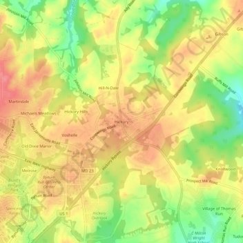
Name: Hickory topographic map, elevation, terrain.
Location: Hickory, Harford County, Maryland, 21050, United States (39.55872 -76.36524 39.59872 -76.32524)
Average elevation: 127 m
Minimum elevation: 82 m
Maximum elevation: 159 m
Thank you for supporting this site ❤️
Make a donation
Make a donation