
Plan d'Asse topographic map
Interactive map
Click on the map to display elevation.
About this map
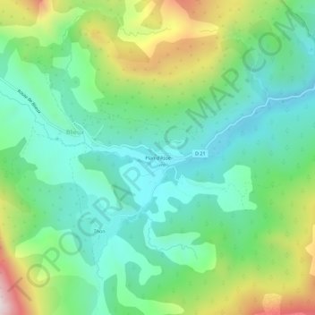
Name: Plan d'Asse topographic map, elevation, terrain.
Average elevation: 1,087 m
Minimum elevation: 842 m
Maximum elevation: 1,643 m
Other topographic maps
Click on a map to view its topography, its elevation and its terrain.
Observatoire du Mont-Chiran
France > Provence-Alpes-Côte d'Azur > Alpes-de-Haute-Provence > Blieux
Observatoire du Mont-Chiran, Majastres-Chiran, Blieux, Castellane, Alpes-de-Haute-Provence, Provence-Alpes-Côte d'Azur, France métropolitaine, 04330, France
Average elevation: 1,525 m
Thon
France > Provence-Alpes-Côte d'Azur > Alpes-de-Haute-Provence > Blieux > Thon
Thon, Blieux, Castellane, Alpes-de-Haute-Provence, Provence-Alpes-Côte d'Azur, France métropolitaine, 04330, France
Average elevation: 1,170 m
Le Chiran
France > Provence-Alpes-Côte d'Azur > Alpes-de-Haute-Provence > Blieux
Le Chiran, Blieux, Castellane, Alpes-de-Haute-Provence, Provence-Alpes-Côte d'Azur, France métropolitaine, 04330, France
Average elevation: 1,527 m
Observatoire-Refuge du Mont Chiran
France > Provence-Alpes-Côte d'Azur > Alpes-de-Haute-Provence > Blieux
Observatoire-Refuge du Mont Chiran, Majastres-Chiran, Blieux, Castellane, Alpes-de-Haute-Provence, Provence-Alpes-Côte d'Azur, France métropolitaine, 04330, France
Average elevation: 1,526 m