
Thank you for supporting this site ❤️
Make a donation
Make a donation
Greeneville topographic map
Click on the map to display elevation.
Thank you for supporting this site ❤️
Make a donation
Make a donation
About this map
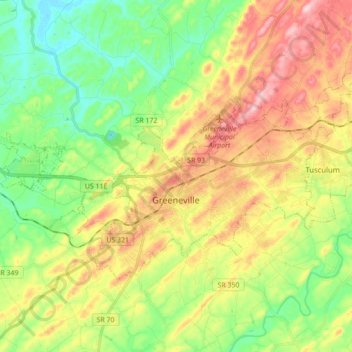
Name: Greeneville topographic map, elevation, terrain.
Average elevation: 435 m
Minimum elevation: 342 m
Maximum elevation: 566 m
Thank you for supporting this site ❤️
Make a donation
Make a donation
Other topographic maps
Click on a map to view its topography, its elevation and its terrain.
Thank you for supporting this site ❤️
Make a donation
Make a donation
Thank you for supporting this site ❤️
Make a donation
Make a donation
Robinson Forest
United States > Tennessee > Greene County > Greeneville > Robinson Forest
Average elevation: 472 m
Andrew Johnson National Historic Site
United States > Tennessee > Greene County > Greeneville > Honeys Hill
Average elevation: 469 m