
美日切错 topographic map
Interactive map
Click on the map to display elevation.
About this map
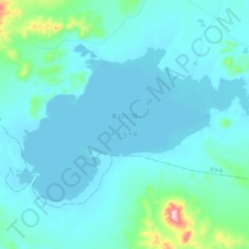
Name: 美日切错 topographic map, elevation, terrain.
Location: 美日切错, 色务, 格尔木市, 海西蒙古族藏族自治州, 青海省, 中国 (33.58850 89.64725 33.68742 89.83806)
Average elevation: 4,993 m
Minimum elevation: 4,947 m
Maximum elevation: 5,430 m
美日切错也作美日切错玛日(標準藏語:མེ་རི་ལྕེ་མཚོ)位于中国西藏自治区北部那曲市双湖县境内,地处双湖县东部,美日切岗根南麓。湖面海拔5354米,面积64平方公里。
Other topographic maps
Click on a map to view its topography, its elevation and its terrain.