
Effeld topographic map
Interactive map
Click on the map to display elevation.
About this map
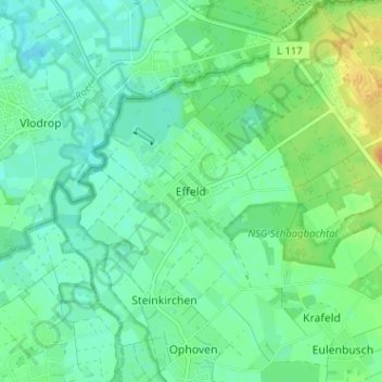
Name: Effeld topographic map, elevation, terrain.
Average elevation: 34 m
Minimum elevation: 24 m
Maximum elevation: 56 m
Other topographic maps
Click on a map to view its topography, its elevation and its terrain.
Birgelen
Deutschland > Nordrhein-Westfalen > Kreis Heinsberg > Wassenberg
Birgelen, Wassenberg, Kreis Heinsberg, Nordrhein-Westfalen, 41849, Deutschland
Average elevation: 56 m
Myhl
Deutschland > Nordrhein-Westfalen > Kreis Heinsberg > Wassenberg
Myhl, Wassenberg, Kreis Heinsberg, Nordrhein-Westfalen, 41849, Deutschland
Average elevation: 82 m