
Bugeat topographic map
Interactive map
Click on the map to display elevation.
About this map
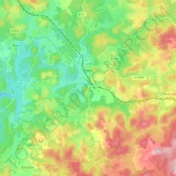
Name: Bugeat topographic map, elevation, terrain.
Average elevation: 739 m
Minimum elevation: 638 m
Maximum elevation: 874 m
Le climat qui caractérise la commune est qualifié, en 2010, de « climat de montagne », selon la typologie des climats de la France qui compte alors huit grands types de climats en métropole. En 2020, la commune ressort du même type de climat dans la classification établie par Météo-France, qui ne compte désormais, en première approche, que cinq grands types de climats en métropole. Pour ce type de climat, la température décroît rapidement en fonction de l'altitude. On observe une nébulosité minimale en hiver et maximale en été. Les vents et les précipitations varient notablement selon le lieu.
Other topographic maps
Click on a map to view its topography, its elevation and its terrain.
Brive-la-Gaillarde
France > Nouvelle-Aquitaine > Corrèze
Brive-la-Gaillarde, Corrèze, Nouvelle-Aquitaine, France métropolitaine, 19100, France
Average elevation: 178 m
Ussel
France > Nouvelle-Aquitaine > Corrèze
Ussel, Corrèze, Nouvelle-Aquitaine, France métropolitaine, 19200, France
Average elevation: 680 m
Saint-Privat
France > Nouvelle-Aquitaine > Corrèze
Saint-Privat, Tulle, Corrèze, Nouvelle-Aquitaine, France métropolitaine, 19220, France
Average elevation: 570 m
Saint-Mexant
France > Nouvelle-Aquitaine > Corrèze
Saint-Mexant, Tulle, Corrèze, Nouvelle-Aquitaine, France métropolitaine, 19330, France
Average elevation: 404 m
Meymac
France > Nouvelle-Aquitaine > Corrèze > Meymac
Meymac, Ussel, Corrèze, Nouvelle-Aquitaine, France métropolitaine, 19250, France
Average elevation: 763 m
Thalamy
France > Nouvelle-Aquitaine > Corrèze > Thalamy
Thalamy, Ussel, Corrèze, Nouvelle-Aquitaine, France métropolitaine, 19200, France
Average elevation: 712 m
Tulle
France > Nouvelle-Aquitaine > Corrèze > Tulle
Tulle, Corrèze, Nouvelle-Aquitaine, France métropolitaine, 19000, France
Average elevation: 321 m
Varetz
France > Nouvelle-Aquitaine > Corrèze > Varetz
Varetz, Brive-la-Gaillarde, Corrèze, Nouvelle-Aquitaine, France métropolitaine, 19240, France
Average elevation: 138 m
Yssandon
France > Nouvelle-Aquitaine > Corrèze > Yssandon
Yssandon, Brive-la-Gaillarde, Corrèze, Nouvelle-Aquitaine, France métropolitaine, 19310, France
Average elevation: 182 m
Allassac
France > Nouvelle-Aquitaine > Corrèze > Allassac
Allassac, Brive-la-Gaillarde, Corrèze, Nouvelle-Aquitaine, France métropolitaine, 19240, France
Average elevation: 217 m