
Everett topographic map
Interactive map
Click on the map to display elevation.
About this map
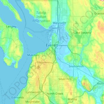
Name: Everett topographic map, elevation, terrain.
Average elevation: 69 m
Minimum elevation: -4 m
Maximum elevation: 420 m
Other topographic maps
Click on a map to view its topography, its elevation and its terrain.
Kennard Corner
États-Unis d'Amérique > Washington > Snohomish County > North Creek
Kennard Corner, North Creek, Snohomish County, Washington, 98205, États-Unis d'Amérique
Average elevation: 92 m
Glacier Peak
États-Unis d'Amérique > Washington > Snohomish County
Glacier Peak, Snohomish County, Washington, États-Unis d'Amérique
Average elevation: 2,656 m