Bellefonte topographic map
Interactive map
Click on the map to display elevation.
About this map
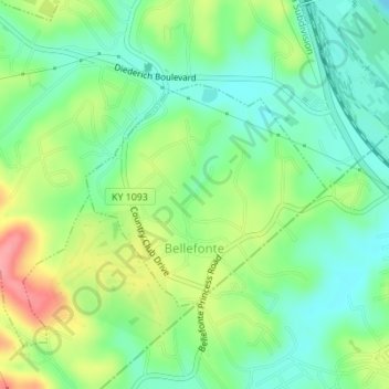
Name: Bellefonte topographic map, elevation, terrain.
Location: Bellefonte, Greenup County, Kentucky, United States (38.48856 -82.69979 38.50399 -82.67844)
Average elevation: 188 m
Minimum elevation: 155 m
Maximum elevation: 246 m
The city is located on a one-mile wide belt of relatively flat land that is approximately 100 feet higher in elevation than the nearby Ohio River valley. The unusual topography which is easily noticeable on topographical maps and aerial satellite imagery was created by the ancient Teays River. Larger than the Ohio River, the Teays cut a mile wide valley through the area before being filled with glacial silt during the ice age. This belt of flat land extends from Catlettsburg where it leaves the Ohio River north to near Wurtland and includes parts of Ashland, Westwood, Bellefonte, Russell and Flatwoods. The Ohio River came after the ice age in its current path which created another valley just northeast of Bellefonte. This entire belt of flat land was once known as The Flatwoods beginning in the mid-19th century. The name was retained when it was applied to the nearby city of Flatwoods, just northwest of Bellefonte.
Other topographic maps
Click on a map to view its topography, its elevation and its terrain.
Load
United States > Kentucky > Greenup County
Load, Greenup County, Kentucky, United States
Average elevation: 222 m
Frost
United States > Kentucky > Greenup County
Frost, Greenup County, Kentucky, 41175, United States
Average elevation: 180 m
Flatwoods
United States > Kentucky > Greenup County
Flatwoods, Greenup County, Kentucky, United States
Average elevation: 194 m
Raceland
United States > Kentucky > Greenup County
Raceland, Greenup County, Kentucky, United States
Average elevation: 185 m
Oldtown
United States > Kentucky > Greenup County
Oldtown, Greenup County, Kentucky, 41122, United States
Average elevation: 205 m
Hunnewell
United States > Kentucky > Greenup County
Hunnewell, Greenup County, Kentucky, 41122, United States
Average elevation: 221 m
Sunshine
United States > Kentucky > Greenup County
Sunshine, Greenup County, Kentucky, 41175, United States
Average elevation: 193 m
Lloyd
United States > Kentucky > Greenup County
Lloyd, Greenup County, Kentucky, 45629, United States
Average elevation: 188 m
Wurtland
United States > Kentucky > Greenup County
Wurtland, Greenup County, Kentucky, United States
Average elevation: 181 m
Worthington
United States > Kentucky > Greenup County
Worthington, Greenup County, Kentucky, 41183, United States
Average elevation: 182 m
Russell
United States > Kentucky > Greenup County
Russell, Greenup County, Kentucky, United States
Average elevation: 192 m
South Shore
United States > Kentucky > Greenup County
South Shore, Greenup County, Kentucky, United States
Average elevation: 190 m
Argillite
United States > Kentucky > Greenup County
Argillite, Greenup County, Kentucky, 41121, United States
Average elevation: 198 m
Greenup
United States > Kentucky > Greenup County
Greenup, Greenup County, Kentucky, United States
Average elevation: 176 m