
Make a donation
Musandam Governorate topographic map
Click on the map to display elevation.
Make a donation
Musandam Governorate
The rugged coastline resembles the glacier-carved coasts of polar regions, but in this case, the coast was shaped by the movement of Earth's crust. The Arabian plate is slowly pushing under the Eurasian plate, creating the earthquake-prone mountains of Iran. On the leading edge of the Arabian plate, the Musandam Peninsula is sinking. The higher elevation mountains remain above the water, but the sea has rushed in to fill the valleys with fingers of water.
Make a donation
About this map
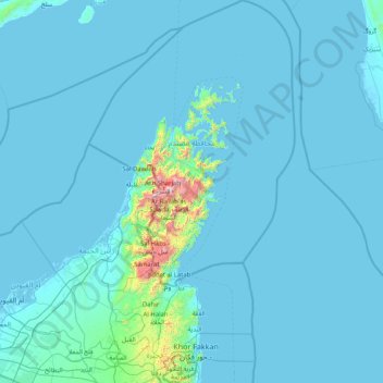
Name: Musandam Governorate topographic map, elevation, terrain.
Location: Musandam Governorate, Oman (25.22719 55.88837 26.70268 56.77154)
Average elevation: 69 m
Minimum elevation: -3 m
Maximum elevation: 2,000 m
Make a donation
Other topographic maps
Click on a map to view its topography, its elevation and its terrain.
Musandam
The rugged coastline resembles the glacier-carved coasts of polar regions, but in this case, the coast was shaped by the movement of Earth's crust. The Arabian Plate is slowly pushing under the Eurasian Plate, creating the earthquake-prone mountains of Iran. On the leading edge of the Arabian Plate, the…
Average elevation: 254 m
Jabal Shams
Oman > Ad Dakhiliyah Governorate
The mountain also has a second summit, the South Summit, which is publicly accessible for trekking via the W4 Trail, marked by the Oman Ministry of Tourism. The elevation of the second south summit is 2,997 m (9,833 ft).
Average elevation: 2,451 m
Jabal Shams
Oman > Ad Dakhiliyah Governorate
The mountain also has a second summit, the South Summit, which is publicly accessible for trekking via the W4 Trail, marked by the Oman Ministry of Tourism. The elevation of the second south summit is 2,997 m (9,833 ft).
Average elevation: 2,451 m
Make a donation
Al Hajar Mountains
Oman > Al Batinah South Governorate
The high topography is around two major culminations: Jabal Akhdar and Saih Hatat, which are large scale anticlines. The Saih Hatat culmination contains eclogite in the northeast at As Sifah. These rocks were subducted to about 80 km (50 mi) depth into the mantle, and then exhumed back to the surface. This…
Average elevation: 2,502 m
Jebel Jais
Oman > Musandam Governorate > Bukha Province
Jebel Jais (Arabic: جبل جيس, romanized: Jabal Jays) is a mountain of the North-Western Hajar range in the Musandam Governorate of Oman and also in Ras Al Khaimah, United Arab Emirates. The summit has an elevation of 1,934 m (6,345 ft). The summit is located on the Omani side, but a high point west of…
Average elevation: 1,580 m
Make a donation
Jebel Jais
Oman > Musandam Governorate > Bukha Province
Jebel Jais (Arabic: جَبَل جَيْس, romanized: Jabal Jays) is a mountain of the North-Western Hajar range in the Musandam Governorate of Oman and also in Ras Al Khaimah, United Arab Emirates. The summit has an elevation of 1,934 m (6,345 ft). The summit is located on the Omani side, but a high point…
Average elevation: 1,580 m
Make a donation
Make a donation
Make a donation
As Saiq
Oman > Ad Dakhiliyah Governorate
Saiq has a cold semi-arid climate (Köppen climate classification: BSk), with hot summers and cool winters. Precipitation is higher, and temperatures are lower, than in many other towns in Oman due to its high altitude in the Al Hajar Mountains. The highest temperature recorded in Saiq is 40.4 °C (104.7 °F),…
Average elevation: 1,887 m
سيح العلا
Oman > Ash Sharqiyah South Governorate > Jaalan Bani Bu Ali Province
Average elevation: 87 m
Make a donation
Izki
Oman > Ad Dakhiliyah Governorate
Izki (Arabic: إِزْكِي) is a town in the Ad Dakhiliyah region of northeastern Oman. It is located at c. 544 m (1,785 ft) altitude, and has a population of 35,173 (2003 census).
Average elevation: 662 m
Make a donation
Make a donation
Bahla Fort
Oman > Ad Dakhiliyah Governorate > Bahla Province
Preservation attempt in 1995 was found to be a renovation not a restoration because the aim of the remodeling was to make the fort look new. This renovation began without prior archaeological, topographic, architectural or technical surveys.
Average elevation: 575 m
Make a donation
Make a donation
Make a donation
Make a donation
Make a donation
Make a donation
Make a donation
Make a donation
Make a donation
Make a donation
Make a donation
Make a donation
Make a donation
Make a donation
Make a donation
Make a donation
Make a donation