
Thank you for supporting this site ❤️
Make a donation
Make a donation
Alcorriol topographic map
Click on the map to display elevation.
Thank you for supporting this site ❤️
Make a donation
Make a donation
About this map
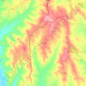
Name: Alcorriol topographic map, elevation, terrain.
Location: Alcorriol, Torres Novas, Santarém, 2350-077, Portugal (39.50497 -8.54352 39.54497 -8.50352)
Average elevation: 113 m
Minimum elevation: 41 m
Maximum elevation: 162 m
Thank you for supporting this site ❤️
Make a donation
Make a donation
Other topographic maps
Click on a map to view its topography, its elevation and its terrain.
Monumento Natural das Pegadas de Dinossáurios de Ourém/Torres Novas
Portugal > Santarém > Torres Novas > Chancelaria
Average elevation: 289 m
Thank you for supporting this site ❤️
Make a donation
Make a donation
Brogueira, Parceiros de Igreja e Alcorochel
Portugal > Santarém > Torres Novas
Average elevation: 78 m
Thank you for supporting this site ❤️
Make a donation
Make a donation