
Thank you for supporting this site ❤️
Make a donation
Make a donation
Pleasant Valley topographic map
Click on the map to display elevation.
Thank you for supporting this site ❤️
Make a donation
Make a donation
About this map
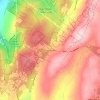
Name: Pleasant Valley topographic map, elevation, terrain.
Average elevation: 462 m
Minimum elevation: 253 m
Maximum elevation: 562 m
Thank you for supporting this site ❤️
Make a donation
Make a donation
Other topographic maps
Click on a map to view its topography, its elevation and its terrain.
Thank you for supporting this site ❤️
Make a donation
Make a donation
Paramount-Long Meadow
United States > Maryland > Washington County > Paramount
Average elevation: 177 m
Thank you for supporting this site ❤️
Make a donation
Make a donation