
Beychevelle topographic map
Interactive map
Click on the map to display elevation.
About this map
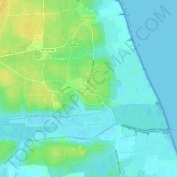
Name: Beychevelle topographic map, elevation, terrain.
Average elevation: 8 m
Minimum elevation: -1 m
Maximum elevation: 26 m
Other topographic maps
Click on a map to view its topography, its elevation and its terrain.
Château Larose Trintaudon
France > Nouvelle-Aquitaine > Gironde > Beychevelle > Le Bourdieu
Château Larose Trintaudon, Grand' Rue, Le Bourdieu, Saint-Julien-Beychevelle, Beychevelle, Lesparre-Médoc, Gironde, Nouvelle-Aquitaine, France métropolitaine, 33112, France
Average elevation: 11 m
Le Bourdieu
France > Nouvelle-Aquitaine > Gironde > Beychevelle
Le Bourdieu, Beychevelle, Saint-Julien-Beychevelle, Lesparre-Médoc, Gironde, Nouvelle-Aquitaine, France métropolitaine, 33250, France
Average elevation: 8 m