
Saint Stephen Parish topographic map
Interactive map
Click on the map to display elevation.
About this map
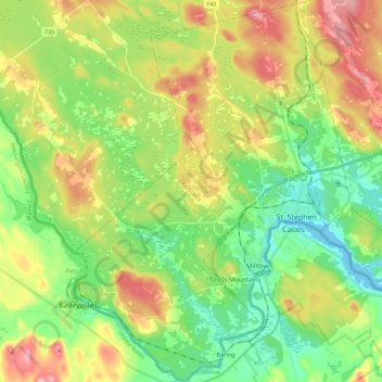
Name: Saint Stephen Parish topographic map, elevation, terrain.
Average elevation: 65 m
Minimum elevation: -1 m
Maximum elevation: 167 m
Other topographic maps
Click on a map to view its topography, its elevation and its terrain.
Lawrence Station
Canada > Nouveau-Brunswick > Comté de Charlotte > Lawrence Station
Lawrence Station, Saint James Parish, Comté de Charlotte, Nouveau-Brunswick, Canada
Average elevation: 110 m
Saint James Parish
Canada > Nouveau-Brunswick > Comté de Charlotte
Saint James Parish, Comté de Charlotte, Nouveau-Brunswick, Canada
Average elevation: 94 m