
Thank you for supporting this site ❤️
Make a donation
Make a donation
Shenendoah City topographic map
Click on the map to display elevation.
Thank you for supporting this site ❤️
Make a donation
Make a donation
About this map
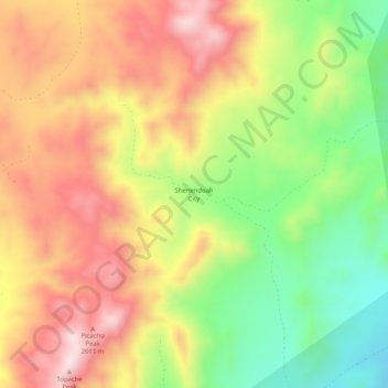
Name: Shenendoah City topographic map, elevation, terrain.
Location: Shenendoah City, Beaver County, Utah, United States (38.33219 -113.15718 38.37219 -113.11718)
Average elevation: 1,851 m
Minimum elevation: 1,592 m
Maximum elevation: 2,097 m
Thank you for supporting this site ❤️
Make a donation
Make a donation
Other topographic maps
Click on a map to view its topography, its elevation and its terrain.