
Make a donation
Antelias topographic map
Click on the map to display elevation.
Make a donation
Antelias
The municipality of Antelias - Naqqach is located in the Kaza of Metn in Mount Lebanon, one of the eight mohafazats (governorates) of Lebanon. Antelias - Naqqach is 8 kilometers (4.9712 mi) from Beyrouth (Beirut), the capital of Lebanon. Its elevation is 10 meters (32.81 ft; 10.936 yd) above sea level. Antelias - Naqqach surface stretches for 193 hectares (1.93 km2 - 0.74498 mi2).
Make a donation
About this map
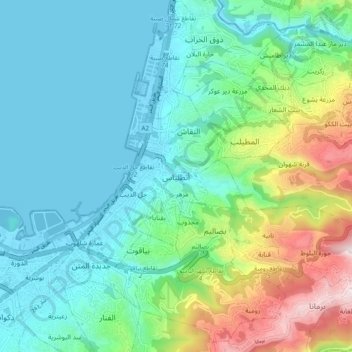
Name: Antelias topographic map, elevation, terrain.
Average elevation: 197 m
Minimum elevation: -4 m
Maximum elevation: 813 m
Make a donation
Other topographic maps
Click on a map to view its topography, its elevation and its terrain.
Make a donation
Beirut River
Lebanon > Mount Lebanon Governorate
During the Stone Age, the land on which Beirut is now built was two islands in the delta of the Beirut River, but over the centuries the river silted up and the two islands were connected into one land mass. The right bank of the Beirut River, southwest of the mountain resort town of Beit Mery at an altitude…
Average elevation: 624 m