
Thank you for supporting this site ❤️
Make a donation
Make a donation
Falset topographic map
Click on the map to display elevation.
Thank you for supporting this site ❤️
Make a donation
Make a donation
About this map
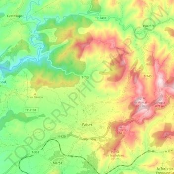
Name: Falset topographic map, elevation, terrain.
Location: Falset, Priorat, Tarragona, Katalonien, 43730, Spanien (41.13386 0.76068 41.18959 0.86337)
Average elevation: 361 m
Minimum elevation: 122 m
Maximum elevation: 668 m
Thank you for supporting this site ❤️
Make a donation
Make a donation
Other topographic maps
Click on a map to view its topography, its elevation and its terrain.