
Thank you for supporting this site ❤️
Make a donation
Make a donation
Mettet topographic map
Click on the map to display elevation.
Thank you for supporting this site ❤️
Make a donation
Make a donation
About this map
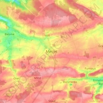
Name: Mettet topographic map, elevation, terrain.
Location: Mettet, Namen, Wallonië, 5640, België (50.28121 4.61849 50.36121 4.69849)
Average elevation: 247 m
Minimum elevation: 179 m
Maximum elevation: 281 m
Thank you for supporting this site ❤️
Make a donation
Make a donation
Other topographic maps
Click on a map to view its topography, its elevation and its terrain.