
Mechtat Ouled Yagoub topographic map
Interactive map
Click on the map to display elevation.
About this map
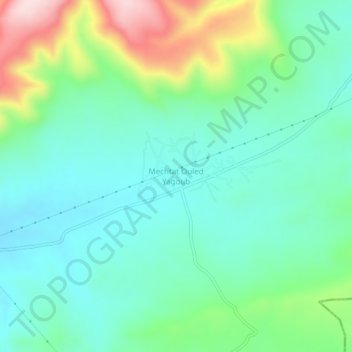
Name: Mechtat Ouled Yagoub topographic map, elevation, terrain.
Location: Mechtat Ouled Yagoub, Oued Seguen, Daïra Teleghma, Mila, Algérie (36.16042 6.43978 36.20042 6.47978)
Average elevation: 855 m
Minimum elevation: 765 m
Maximum elevation: 1,097 m