
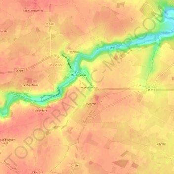
Vaucouleur topographic map
Interactive map
Click on the map to display elevation.
About this map
Name: Vaucouleur topographic map, elevation, terrain.
Average elevation: 93 m
Minimum elevation: 52 m
Maximum elevation: 105 m
Other topographic maps
Click on a map to view its topography, its elevation and its terrain.
La Maynie
France > Nouvelle-Aquitaine > Deux-Sèvres > Val en Vignes > La Maynie
La Maynie, Massais, Val en Vignes, Bressuire, Deux-Sèvres, Nouvelle-Aquitaine, France métropolitaine, 79150, France
Average elevation: 93 m
Le Pain Bénit
France > Nouvelle-Aquitaine > Deux-Sèvres > Val en Vignes > Le Pain Bénit
Le Pain Bénit, Massais, Val en Vignes, Bressuire, Deux-Sèvres, Nouvelle-Aquitaine, France métropolitaine, 79150, France
Average elevation: 96 m
Cersay
France > Nouvelle-Aquitaine > Deux-Sèvres > Val en Vignes
Cersay, Val en Vignes, Bressuire, Deux-Sèvres, Nouvelle-Aquitaine, France métropolitaine, 79290, France
Average elevation: 87 m
Massais
France > Nouvelle-Aquitaine > Deux-Sèvres > Val en Vignes
Massais, Val en Vignes, Bressuire, Deux-Sèvres, Nouvelle-Aquitaine, France métropolitaine, 79150, France
Average elevation: 100 m
Bouillé-Saint-Paul
France > Nouvelle-Aquitaine > Deux-Sèvres > Val en Vignes
Bouillé-Saint-Paul, Val en Vignes, Bressuire, Deux-Sèvres, Nouvelle-Aquitaine, France métropolitaine, 79290, France
Average elevation: 74 m