
Make a donation
Lake Huron topographic map
Click on the map to display elevation.
Make a donation
Lake Huron
Lake Huron (/ˈhjʊərɒn, -ən/ HURE-on, -ən) is one of the five Great Lakes of North America. Hydrologically, it comprises the easterly portion of Lake Michigan–Huron, having the same surface elevation as Lake Michigan, to which it is connected by the 5-mile-wide (8.0 km), 20-fathom-deep (120 ft; 37 m) Straits of Mackinac. It is shared on the north and east by the Canadian province of Ontario and on the south and west by the U.S. state of Michigan. The name of the lake is derived from early French explorers who named it for the Huron people inhabiting the region.
Make a donation
About this map
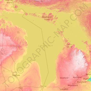
Name: Lake Huron topographic map, elevation, terrain.
Location: Lake Huron, Canada (43.00088 -84.77307 46.29953 -79.65391)
Average elevation: 230 m
Minimum elevation: 73 m
Maximum elevation: 535 m
Make a donation
Other topographic maps
Click on a map to view its topography, its elevation and its terrain.
Toronto
Despite its deep ravines, Toronto is not remarkably hilly, but its elevation does increase steadily away from the lake. Elevation differences range from 76.5 metres (251 ft) above sea level at the Lake Ontario shore to 209 m (686 ft) ASL near the York University grounds in the city's north end at the…
Average elevation: 113 m
Banff
Canada > Alberta > Banff > Banff
Banff is a town within Banff National Park in Alberta, Canada. It is located in Alberta's Rockies along the Trans-Canada Highway, approximately 126 km (78 mi) west of Calgary and 58 km (36 mi) east of Lake Louise. At 1,400 to 1,630 m (4,590 to 5,350 ft) above sea level, Banff is the community with the second…
Average elevation: 1,615 m
Make a donation
Mount Royal
Canada > Quebec > Urban agglomeration of Montreal > Montreal
The hill is part of the Monteregian Hills situated between the Laurentians and the Appalachian Mountains. It gave its Latin name, Mons Regius, to the Monteregian chain. The hill consists of three peaks: Colline de la Croix (or Mont Royal proper) at 233 m (764 ft), Colline d'Outremont (or Mount Murray, in the…
Average elevation: 111 m
Whistler
Canada > British Columbia > Squamish-Lillooet Regional District > Whistler Resort Municipality > Whistler
Average elevation: 996 m
Port Coquitlam
Canada > British Columbia > Metro Vancouver Regional District > Port Coquitlam
Average elevation: 185 m
Make a donation
Mayor Island
Canada > British Columbia > Regional District of Mount Waddington > Area A (Seymour Inlet/Knight Inlet)
Average elevation: 5 m
Make a donation
Fraser River
Canada > British Columbia > Fraser Valley Regional District > Chilliwack > Minto Landing
Average elevation: 100 m
Big Lake Ranch
Canada > British Columbia > Cariboo Regional District > Area F (Horsefly/Likely/150 Mile House)
Average elevation: 908 m
Make a donation
Make a donation
Quebec
Canada > Quebec > Urban agglomeration of Québec
Quebec City was built on the north bank of the Saint Lawrence River, where it narrows and meets the mouth of the Saint-Charles River. Old Quebec is located on top and at the foot of Cap-Diamant, which is on the eastern edge of a plateau called the promontory of Quebec (Quebec hill). Because of this topographic…
Average elevation: 100 m
Hudson Bay Mountain
Canada > British Columbia > Regional District of Bulkley-Nechako > Area A (Hudson Bay Mountain)
Average elevation: 2,064 m
Make a donation
Sonora Park
Canada > British Columbia > Regional District of Central Okanagan > Kelowna
Average elevation: 418 m
Make a donation
Make a donation
Pittston
Canada > Ontario > Leeds and Grenville Counties > Edwardsburgh/Cardinal
Average elevation: 82 m
Pinawa
Canada > Manitoba > Division No. 1 > Local Government District of Pinawa
Average elevation: 277 m
Make a donation
Ellsmere Island
Canada > Ontario > Parry Sound District > The Archipelago Township
Average elevation: 197 m
Denarta Park
Canada > British Columbia > Regional District of Kitimat-Stikine > Area C (Butedale/Kitlope/Kitsumkalum)
Average elevation: 155 m
Make a donation
Make a donation
Saint Andrews
Canada > New Brunswick > Charlotte County > Town of Saint Andrews
Average elevation: 7 m
Mount Royal Park
Canada > Quebec > Urban agglomeration of Montreal > Montreal
The mountain is part of the Monteregian Hills situated between the Laurentians and the Appalachian Mountains. It gave its Latin name, Mons Regius, to the Monteregian chain. The mountain consists of three peaks: Colline de la Croix (or Mont Royal proper) at 233 m (764 ft), Colline d'Outremont (or Mount Murray,…
Average elevation: 110 m
Blue Lake
Canada > British Columbia > Regional District of East Kootenay > Area A (Upper Flathead/Elk Valley)
Average elevation: 1,430 m
Make a donation
Silverthrone Mountain
Canada > British Columbia > Regional District of Mount Waddington > Area A (Seymour Inlet/Knight Inlet)
Mount Silverthrone is perhaps one of the most heavily is perhaps one of the most heavily glaciated volcanic peaks in southwestern British Columbia. It has a topographic prominence of approximately 975 m (3,200 ft), greater than any other volcano in southwestern British Columbia. The extensive icefields around…
Average elevation: 2,297 m
Make a donation
Topaz Lake
Canada > British Columbia > Regional District of East Kootenay > Area G (Forster Creek/Mount Assiniboine)
Average elevation: 1,149 m
Make a donation
Cultus Lake
Canada > British Columbia > Fraser Valley Regional District > Area H (Cultus Lake/Columbia Valley) > Cultus Lake
Average elevation: 191 m
The Copilot
Canada > British Columbia > Squamish-Lillooet Regional District > Area D (Elaho/Garibaldi)
Average elevation: 1,468 m
Make a donation
Turtle Mountain Provincial Park
Canada > Manitoba > Municipality of Boissevain-Morton
Average elevation: 662 m
Ghost Peak
Canada > British Columbia > Columbia-Shuswap Regional District > Area B (Shelter Bay/Mica Creek)
Average elevation: 2,101 m
Make a donation
St. Helena Island
Canada > Ontario > Leeds and Grenville Counties > Front of Yonge
Average elevation: 115 m
Make a donation
Make a donation
Make a donation
Namu
Canada > British Columbia > Central Coast Regional District > Area A (Ocean Falls/Outer Coast)
Average elevation: 126 m
Make a donation
Make a donation
Make a donation
Loveland Lake
Canada > Ontario > Kenora District > Unorganized Kenora District
Average elevation: 426 m
Big Lake
Canada > British Columbia > Cariboo Regional District > Area J (West Chilcotin)
Average elevation: 1,330 m
Tsay Keh Dene Nation
Canada > British Columbia > Peace River Regional District > Area B (Finlay Valley/Beatton Valley)
Average elevation: 688 m
Make a donation
Make a donation
Galbraith Lake
Canada > Ontario > Kenora District > Unorganized Kenora District
Average elevation: 455 m
Mount Connor
Canada > British Columbia > Regional District of East Kootenay > Area A (Upper Flathead/Elk Valley)
Average elevation: 2,466 m
Make a donation