
Tbilisi topographic map
Interactive map
Click on the map to display elevation.
Tbilisi
Most of the raions are named after historic quarters of the city. The citizens of Tbilisi widely recognise an informal system of smaller historic neighbourhoods. Such neighbourhoods are several, however, constituting a kind of hierarchy, because most of them have lost their distinctive topographic limits. The natural first level of subdivision of the city is into the Right Bank and the Left Bank of the Mt'k'vari.
About this map
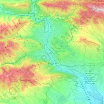
Name: Tbilisi topographic map, elevation, terrain.
Location: Tbilisi, Georgia (41.62039 44.59672 41.84342 45.01801)
Average elevation: 757 m
Minimum elevation: 330 m
Maximum elevation: 1,713 m
Other topographic maps
Click on a map to view its topography, its elevation and its terrain.