
Thank you for supporting this site ❤️
Make a donation
Make a donation
Mahad topographic map
Click on the map to display elevation.
Thank you for supporting this site ❤️
Make a donation
Make a donation
About this map
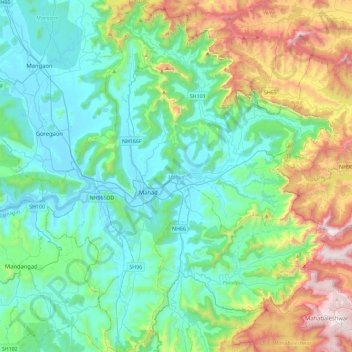
Name: Mahad topographic map, elevation, terrain.
Location: Mahad, Raigad District, Maharashtra, India (17.88197 73.28422 18.31880 73.66651)
Average elevation: 342 m
Minimum elevation: 1 m
Maximum elevation: 1,427 m
Thank you for supporting this site ❤️
Make a donation
Make a donation
Other topographic maps
Click on a map to view its topography, its elevation and its terrain.
Chandoli National Park
India > Maharashtra > Shirala
The park spreads along the crest of the Sahyadri Range of the northern Western Ghats. It forms and protects many perennial water channels, water holes and the Vasant Sagar Reservoir. Elevation of the park ranges from 589–1,044 m (1,932–3,425 ft). The park receives its water supply from the Warna river and…
Average elevation: 749 m
Thank you for supporting this site ❤️
Make a donation
Make a donation