
Isle Royale topographic map
Interactive map
Click on the map to display elevation.
About this map
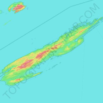
Name: Isle Royale topographic map, elevation, terrain.
Location: Isle Royale, Keweenaw County, Michigan, United States (47.82376 -89.23555 48.19102 -88.42232)
Average elevation: 190 m
Minimum elevation: 176 m
Maximum elevation: 443 m
According to the Köppen climate classification system, Isle Royale National Park has a mild summer Humid continental climate (Dfb). According to the United States Department of Agriculture, the Plant Hardiness zone is 4b at 1178 ft (359 m) elevation with an average annual extreme minimum temperature of -24.2 °F (-31.2 °C).
Other topographic maps
Click on a map to view its topography, its elevation and its terrain.
Grant Township
United States > Michigan > Keweenaw County
Grant Township, Keweenaw County, Michigan, 49918, United States
Average elevation: 220 m