
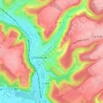
La Côte Blanche topographic map
Interactive map
Click on the map to display elevation.
About this map
Name: La Côte Blanche topographic map, elevation, terrain.
Average elevation: 78 m
Minimum elevation: 0 m
Maximum elevation: 139 m
Other topographic maps
Click on a map to view its topography, its elevation and its terrain.
Les Herbages
France > Normandie > Seine-Maritime > Lillebonne
Les Herbages, Lillebonne, Le Havre, Seine-Maritime, Normandie, France métropolitaine, 76170, France
Average elevation: 7 m
Le Manoir
France > Normandie > Seine-Maritime > Lillebonne
Le Manoir, Lillebonne, Le Havre, Seine-Maritime, Normandie, France métropolitaine, 76170, France
Average elevation: 65 m