
Intervale topographic map
Interactive map
Click on the map to display elevation.
About this map
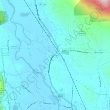
Name: Intervale topographic map, elevation, terrain.
Average elevation: 198 m
Minimum elevation: 138 m
Maximum elevation: 670 m
Other topographic maps
Click on a map to view its topography, its elevation and its terrain.
North Conway
United States > New Hampshire > Carroll County > Conway
North Conway, Conway, Carroll County, New Hampshire, 03860, United States
Average elevation: 173 m
Center Conway
United States > New Hampshire > Carroll County > Conway
Center Conway, Conway, Carroll County, New Hampshire, 03813, United States
Average elevation: 142 m
Kearsarge
United States > New Hampshire > Carroll County > Conway
Kearsarge, Conway, Carroll County, New Hampshire, 03847, United States
Average elevation: 272 m
Redstone
United States > New Hampshire > Carroll County > Conway
Redstone, Conway, Carroll County, New Hampshire, 03860, United States
Average elevation: 185 m
Mount Washington Valley
United States > New Hampshire > Carroll County > Conway > North Conway
Mount Washington Valley, North Conway, Conway, Carroll County, New Hampshire, 03860, United States
Average elevation: 250 m