
Thank you for supporting this site ❤️
Make a donation
Make a donation
Wilderen topographic map
Click on the map to display elevation.
Thank you for supporting this site ❤️
Make a donation
Make a donation
Wilderen
Wilderen ligt in Vochtig-Haspengouw. De hoogte bedraagt 40 à 50 meter en het buitengebied bestaat vooral uit boomgaarden ten behoeve van de fruitteelt.
Thank you for supporting this site ❤️
Make a donation
Make a donation
About this map
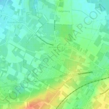
Name: Wilderen topographic map, elevation, terrain.
Location: Wilderen, Sint-Truiden, Hasselt, Limburg, 3803, België (50.80906 5.13031 50.82631 5.16132)
Average elevation: 47 m
Minimum elevation: 32 m
Maximum elevation: 73 m
Thank you for supporting this site ❤️
Make a donation
Make a donation
Other topographic maps
Click on a map to view its topography, its elevation and its terrain.
Thank you for supporting this site ❤️
Make a donation
Make a donation
Thank you for supporting this site ❤️
Make a donation
Make a donation