
Pinetown topographic map
Click on the map to display elevation.
Pinetown
Pinetown is mostly hilly, apart from the relatively flat central business district. The eastern areas, including Cowies Hill and the New Germany Nature Reserve, rise to about 400 m (1,312 ft) above sea level. In the north, Berkshire Downs in New Germany reaches around 393 m (1,289 ft). The lowest elevations, ranging between 170 m (558 ft) and 300 m (984 ft), are found in the southern parts of Pinetown.
About this map
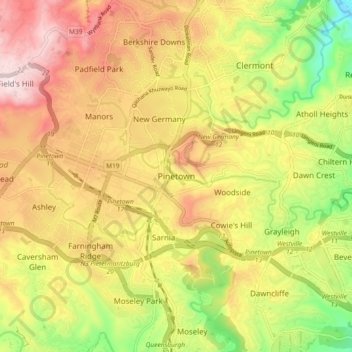
Name: Pinetown topographic map, elevation, terrain.
Average elevation: 296 m
Minimum elevation: 13 m
Maximum elevation: 554 m
Other topographic maps
Click on a map to view its topography, its elevation and its terrain.
Inanda Dam
South Africa > KwaZulu-Natal > eThekwini Metropolitan Municipality
Average elevation: 222 m
Umgeni River
South Africa > KwaZulu-Natal > eThekwini Metropolitan Municipality > Queensburgh
Average elevation: 131 m
Izinga Walkways
South Africa > KwaZulu-Natal > eThekwini Metropolitan Municipality > Umhlanga Rocks
Average elevation: 94 m
Pigeon Valley
South Africa > KwaZulu-Natal > eThekwini Metropolitan Municipality > Durban
Average elevation: 69 m
uMngeni River
South Africa > KwaZulu-Natal > eThekwini Metropolitan Municipality
Average elevation: 598 m
Umgeni River
South Africa > KwaZulu-Natal > eThekwini Metropolitan Municipality > Queensburgh
Average elevation: 155 m
Molweni River
South Africa > KwaZulu-Natal > eThekwini Metropolitan Municipality > Forest Hills
Average elevation: 227 m
Umbilo River
South Africa > KwaZulu-Natal > eThekwini Metropolitan Municipality > Durban
Average elevation: 56 m
Bluff Nature Reserve
South Africa > KwaZulu-Natal > eThekwini Metropolitan Municipality > Durban
Average elevation: 38 m
Umhlanga River
South Africa > KwaZulu-Natal > eThekwini Metropolitan Municipality > Phoenix
Average elevation: 130 m
Umbilo River
South Africa > KwaZulu-Natal > eThekwini Metropolitan Municipality > Pinetown
Average elevation: 337 m
Palmiet River
South Africa > KwaZulu-Natal > eThekwini Metropolitan Municipality > Pinetown
Average elevation: 308 m
eThekwini Ward 32
South Africa > KwaZulu-Natal > eThekwini Metropolitan Municipality
Average elevation: 25 m
Umgeni River
South Africa > KwaZulu-Natal > eThekwini Metropolitan Municipality > Queensburgh
Average elevation: 131 m
Umbilo River
South Africa > KwaZulu-Natal > eThekwini Metropolitan Municipality > Durban
Average elevation: 56 m
uMngeni River
South Africa > KwaZulu-Natal > eThekwini Metropolitan Municipality
Average elevation: 598 m
Plantations
South Africa > KwaZulu-Natal > eThekwini Metropolitan Municipality > Hillcrest
Average elevation: 631 m