
Fredericksburg topographic map
Interactive map
Click on the map to display elevation.
About this map
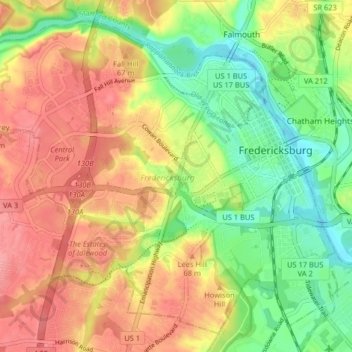
Name: Fredericksburg topographic map, elevation, terrain.
Location: Fredericksburg, Virginia, United States (38.27015 -77.53259 38.32664 -77.44679)
Average elevation: 38 m
Minimum elevation: -2 m
Maximum elevation: 82 m
Other topographic maps
Click on a map to view its topography, its elevation and its terrain.
Arlington
United States > Virginia > Arlington County
Arlington, Arlington County, Virginia, United States
Average elevation: 51 m
Oakton
United States > Virginia > Fairfax County
Oakton, Fairfax County, Virginia, 20030, United States
Average elevation: 114 m
Stafford County
Stafford County, Virginia, United States
Average elevation: 61 m
Loudoun County
Loudoun County, Virginia, United States
Average elevation: 150 m
Crozet
United States > Virginia > Albemarle County > Crozet
Crozet, Albemarle County, Virginia, 23932, United States
Average elevation: 234 m
Reston
United States > Virginia > Fairfax County
Reston, Fairfax County, Virginia, United States
Average elevation: 110 m
Winchester
Winchester, Virginia, 22601, United States
Average elevation: 226 m
Blacksburg
United States > Virginia > Montgomery County
Blacksburg, Montgomery County, Virginia, United States
Average elevation: 621 m
Virginia Beach
United States > Virginia > Virginia Beach
Virginia Beach, Virginia, 23451, United States
Average elevation: 2 m
Richmond City
United States > Virginia > Richmond City
Richmond, Richmond City, Virginia, 23298, United States
Average elevation: 53 m
Goochland County
Goochland County, Virginia, United States
Average elevation: 90 m
Chesterfield County
Chesterfield County, Virginia, United States
Average elevation: 63 m
Shenandoah National Park
United States > Virginia > Page County
Shenandoah National Park, Page County, Virginia, United States
Average elevation: 335 m
Albemarle County
Albemarle County, Virginia, United States
Average elevation: 258 m
Christiansburg
United States > Virginia > Montgomery County
Christiansburg, Montgomery County, Virginia, United States
Average elevation: 620 m
Charlottesville
Charlottesville, Virginia, United States
Average elevation: 138 m
Montgomery County
Montgomery County, Virginia, United States
Average elevation: 657 m
Suffolk
United States > Virginia > Suffolk (city)
Suffolk, Suffolk (city), Virginia, United States
Average elevation: 13 m
Gloucester County
Gloucester County, Virginia, United States
Average elevation: 13 m
Spotsylvania County
Spotsylvania County, Virginia, United States
Average elevation: 87 m
Roseville
United States > Virginia > Stafford County
Roseville, Stafford County, Virginia, 22556, United States
Average elevation: 86 m
Kempsville Colony
United States > Virginia > Virginia Beach
Kempsville Colony, Virginia Beach, Virginia, 23462, United States
Average elevation: 7 m
Bellwood Meadows
United States > Virginia > Virginia Beach
Bellwood Meadows, Virginia Beach, Virginia, 23453, United States
Average elevation: 6 m
Tazewell
United States > Virginia > Tazewell County
Tazewell, Tazewell County, Virginia, United States
Average elevation: 805 m
Front Royal
United States > Virginia > Warren County
Front Royal, Warren County, Virginia, United States
Average elevation: 194 m
Ashburn
United States > Virginia > Loudoun County
Ashburn, Loudoun County, Virginia, United States
Average elevation: 85 m
Frederick County
Frederick County, Virginia, United States
Average elevation: 288 m
Fairfax County
Fairfax County, Virginia, United States
Average elevation: 75 m
Powhatan County
Powhatan County, Virginia, United States
Average elevation: 87 m
Richardson
United States > Virginia > Mecklenburg County
Richardson, Mecklenburg County, Virginia, United States
Average elevation: 102 m
Culpeper County
Culpeper County, Virginia, United States
Average elevation: 141 m
Tangier Island
United States > Virginia > Accomack County > Tangier
Tangier Island, Tangier, Accomack County, Virginia, 23440, United States
Average elevation: 2 m
Cochran
United States > Virginia > Brunswick County > Alberta
Cochran, Alberta, Brunswick County, Virginia, 23821, United States
Average elevation: 101 m
Kilby
United States > Virginia > Suffolk (city) > Suffolk
Kilby, Suffolk, Suffolk (city), Virginia, 23434, United States
Average elevation: 17 m
Montgomery
United States > Virginia > Montgomery County
Montgomery, Montgomery County, Virginia, United States
Average elevation: 584 m
Tiptop
United States > Virginia > Tazewell County
Tiptop, Tazewell County, Virginia, United States
Average elevation: 864 m
Moorings
United States > Virginia > Surry County
Moorings, Surry County, Virginia, 23846, United States
Average elevation: 31 m
Collinsville
United States > Virginia > Henry County
Collinsville, Henry County, Virginia, 24078, United States
Average elevation: 267 m
Alanton
United States > Virginia > Virginia Beach
Alanton, Virginia Beach, Virginia, 23451, United States
Average elevation: 5 m
Groveton
United States > Virginia > Fairfax County
Groveton, Fairfax County, Virginia, 22036, United States
Average elevation: 40 m
Owensville
United States > Virginia > Albemarle County
Owensville, Albemarle County, Virginia, United States
Average elevation: 173 m
Glasgow
United States > Virginia > Rockbridge County
Glasgow, Rockbridge County, Virginia, United States
Average elevation: 284 m