
Thank you for supporting this site ❤️
Make a donation
Make a donation
Buggenhout topographic map
Click on the map to display elevation.
Thank you for supporting this site ❤️
Make a donation
Make a donation
Buggenhout
Buggenhout ligt op een hoogte van 6-29 meter. Een belangrijk natuurgebied is het Buggenhoutbos.
Thank you for supporting this site ❤️
Make a donation
Make a donation
About this map
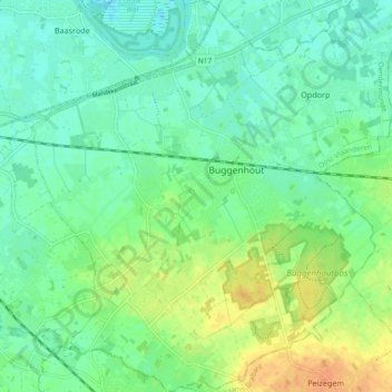
Name: Buggenhout topographic map, elevation, terrain.
Average elevation: 12 m
Minimum elevation: -1 m
Maximum elevation: 32 m
Thank you for supporting this site ❤️
Make a donation
Make a donation
Other topographic maps
Click on a map to view its topography, its elevation and its terrain.
Hondenlosloopzone Buggenhoutbos
België > Oost-Vlaanderen > Dendermonde > Buggenhout
Average elevation: 21 m