
Sorgue topographic map
Interactive map
Click on the map to display elevation.
About this map
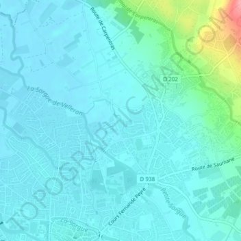
Name: Sorgue topographic map, elevation, terrain.
Average elevation: 69 m
Minimum elevation: 53 m
Maximum elevation: 160 m
Other topographic maps
Click on a map to view its topography, its elevation and its terrain.
La Sorgue
France > Provence-Alpes-Côte d'Azur > Vaucluse > L'Isle-sur-la-Sorgue
La Sorgue, L'Isle-sur-la-Sorgue, Avignon, Vaucluse, Provence-Alpes-Côte d'Azur, France métropolitaine, 84800, France
Average elevation: 60 m
La Sorgue
France > Provence-Alpes-Côte d'Azur > Vaucluse > L'Isle-sur-la-Sorgue
La Sorgue, L'Isle-sur-la-Sorgue, Avignon, Vaucluse, Provence-Alpes-Côte d'Azur, France métropolitaine, 84800, France
Average elevation: 60 m