
Thank you for supporting this site ❤️
Make a donation
Make a donation
Lake Huntington topographic map
Click on the map to display elevation.
Thank you for supporting this site ❤️
Make a donation
Make a donation
About this map
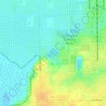
Name: Lake Huntington topographic map, elevation, terrain.
Average elevation: 11 m
Minimum elevation: -7 m
Maximum elevation: 29 m
Thank you for supporting this site ❤️
Make a donation
Make a donation
Other topographic maps
Click on a map to view its topography, its elevation and its terrain.
Huntington Beach
United States > California > Orange County > Huntington Beach
Average elevation: 16 m