
Thank you for supporting this site ❤️
Make a donation
Make a donation
Döhren topographic map
Click on the map to display elevation.
Thank you for supporting this site ❤️
Make a donation
Make a donation
About this map
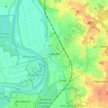
Name: Döhren topographic map, elevation, terrain.
Average elevation: 44 m
Minimum elevation: 27 m
Maximum elevation: 74 m
Thank you for supporting this site ❤️
Make a donation
Make a donation
Other topographic maps
Click on a map to view its topography, its elevation and its terrain.
32469
Deutschland > Nordrhein-Westfalen > Kreis Minden-Lübbecke > Petershagen > Ilse
Average elevation: 50 m
Jössen
Deutschland > Nordrhein-Westfalen > Kreis Minden-Lübbecke > Petershagen
Average elevation: 41 m
Gorspen-Vahlsen
Deutschland > Nordrhein-Westfalen > Kreis Minden-Lübbecke > Petershagen > Gorspen-Vahlsen
Average elevation: 44 m
Eldagsen
Deutschland > Nordrhein-Westfalen > Kreis Minden-Lübbecke > Petershagen
Average elevation: 51 m
Thank you for supporting this site ❤️
Make a donation
Make a donation