
Thank you for supporting this site ❤️
Make a donation
Make a donation
Khanola topographic map
Click on the map to display elevation.
Thank you for supporting this site ❤️
Make a donation
Make a donation
About this map
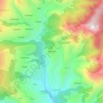
Name: Khanola topographic map, elevation, terrain.
Location: Khanola, Bhot, Rohru, Shimla, Himachal Pradesh, India (31.24397 77.67875 31.28397 77.71875)
Average elevation: 2,147 m
Minimum elevation: 1,768 m
Maximum elevation: 2,720 m
Thank you for supporting this site ❤️
Make a donation
Make a donation