
Thank you for supporting this site ❤️
Make a donation
Make a donation
Étables-sur-Mer topographic map
Click on the map to display elevation.
Thank you for supporting this site ❤️
Make a donation
Make a donation
About this map
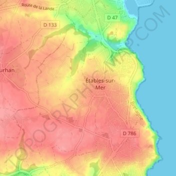
Name: Étables-sur-Mer topographic map, elevation, terrain.
Average elevation: 47 m
Minimum elevation: 0 m
Maximum elevation: 82 m
Thank you for supporting this site ❤️
Make a donation
Make a donation
Other topographic maps
Click on a map to view its topography, its elevation and its terrain.
La Ville Jacob
France > Bretagne > Côtes-d'Armor > Binic-Étables-sur-Mer > Binic
Average elevation: 55 m
Plage de la Banche
France > Bretagne > Côtes-d'Armor > Binic-Étables-sur-Mer > Binic
Average elevation: 34 m